Current meteorological data
Air temperature: 54.14 (°F)
12.3 (°C)
Wind speed:21 (km/h)
Wind direction: W-S-W, 239.5 °
Global radiation: 191.9 (W/m²)
Act. UV-Index: 0.2
Precipitation: 0.0 (ltr/m²)
(Updated: 03/28/2024, 17:30,
S-Mitte, Amt für Umweltschutz
More meteorological data
More about weather Stuttgart
Current sun location
Webcams in Stuttgart
Weather forecast Stuttgart 
Weather forecast Europe 
Weather radar Germany 
More links

News and current events
News about the Stuttgart noise action plan, update 2025 and Tempo-30 reports (German)
Update 2025
Meteorological Annual Report 2023, Stuttgart Hohenheim
Annual Report 2023
Climate Center Stuttgart
Climate Dashboard Stuttgart
Summer Days and Hot Days in Stuttgart (until 2023)
Air: Press releases (German)
UV-Index Prognosis (BfS)
Urban climate Viewer: Maps and plans with detailed thematic maps on climate, air and noise
Noise Maps Stuttgart 2022
Noise action plan Stuttgart
Clean air plan Stuttgart
NO2 and PM10 exceedances
Current measurements from the stations (LUBW)
Picture gallery      More news
5. Thermal maps
Scanning technology


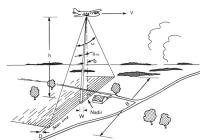
Fig. 5.2: Geometry of the line scanner
Radiometric surface measurements from an aircraft are carried out in the field of meteorology exclusively in "windows", i.e. spectral ranges with low atmospheric absorption. The ranges between 3 and 5 µm and between 8 and 14 µm are suitable for the measurements.

It is possible to determine the ground's temperature by measuring the heat it releases. If you use an aircraft with a line scanner for this purpose, you get an extensive distribution of the surface temperatures.

The present case of the thermal picture of the neighbourhood association Stuttgart is based on measurements between 8 and 14 µm.

Figure 5.2 is a schematic representation of how the landscape is scanned and how measuring points next to one another become chronological electrical measuring signals of the emitted infrared radiation.

Digital imaging

The received measurement data was recorded on magnetic tape and digitized later. This allowed for a processing on modern image processing systems. An equalization through many control points was necessary to scale the pictures.


Information on the infrared measuring flights

Scanning technology and flight data

The measuring flights with infrared thermography were carried out by EUROSENSE (Aachen) and took place during the night of 18/19 August 1988. The Dornier Do 2288-101 aircraft flew over the area under investigation at a flight level of 3,000 m above ground on 18 August from 9:34 pm to 0:03 am (sunset at 8:33 pm) and on 19 August from 3:32 am to 5:32 am (sunsrise at 6:21 am).

The multispectral line scanner in the aircraft was a Daedalus 1268 in the thermal infrared channel with spectral limits of 8 to 13.5 micrometers. The calibration was carried out via two interior black bodies which were temperature stabilized (and which were stabilized in turn against laboratory standards).

At the indicated flight level and the current range of vision of the scanner of 2.5 milliradians, a ground resolution of 7.5 by 7.5 m is achieved in the nadir.

The measuring arrangement can capture temperature differences of the earth's surface of the order of 0.05 K.

The thermal maps from 18 and 19 August 1988 were analysed in steps of 1 degree also for practical reasons and they cover the range from 53.6 °F (12 °C) to 71.6 °F (22 °C) (represented in 11 colour shades).


© City of Stuttgart, Office for Environmental Protection, Section of Urban Climatology