Wind is characterized by its speed and its direction. It regulates the spreading of air pollutants and therefore plays a decisive role for air hygiene. A major element of Stuttgart's climate is the light wind, a fact which is not only the result of the city's position between two bights of the Keuper plains. The whole Neckar Valley is known for low wind speeds and very frequent lulls. This is the result of small air pressure differences common to Southern Germany and of Stuttgart's sheltered position between the Black Forest, the Swabian Alb, the Schurwald and the Swabian-Franconian Forest.
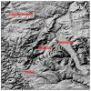
Due to topographic conditions, it is impossible to indicate a consistent wind rose for the whole of Stuttgart. What is the most likely wind rose to describe the local wind is the wind rose at Stuttgart airport. For the rest, there is another wind in every place. The sheltered position between the surrounding mountain ranges lead to a frequent development of local wind systems, especially at the slopes and in the valleys. Even if these winds have no high wind speeds, they play a significant role for the local air supply in some city districts.
As a result of the various topographic distinctions in the region of Stuttgart, significant local modifications of the low winds are to be expected for both higher wind speeds (dynamically dominated, supraregional wind regime) and lower wind speeds (formation of thermal wind systems). As it is impossible to measure the wind "in every place", an evident way to define the wind field is computer based model calculation.
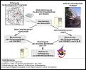
In order to define supraregional winds, we use "DiWiMo2", a diagnostic wind field model.
"DiWiMo2" is based on the theories of N. Moussiopoulos, Th. Flassak and G. Knittel (1988) and was further developed by the Dr. A. Lohmeyer Engineering Office. A diagnostic wind field model is a model for calculating a flow field in a topographically structured region on the basis of wind measurements. Obstacles, like buildings, trees and walls, are not directly eliminated but are considered as topographic surface roughnesses. Diagnostic models require little disk space and calculating time and thus work very well with online calculations.
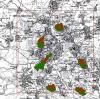
"DiWiMo2" uses wind measurement data collected in the city of Stuttgart and updated every 30 minutes. The individual measuring stations have been selected in order to represent typical topographic zones of Stuttgart. That way, the Schwabenzentrum measuring station (St) stands for the topography of the city basin, the Geschwister-Scholl-Gymnasium station (GS) for the Filder plains, the Feuerwache Bad Cannstatt station (Fw) for the Neckar Valley and the Berger Tunnel station (Bt) for the transition between city basin and Neckar Valley.
"DiWiMo2" works out a vertical wind profile and interpolates and extrapolates between the data in order to receive a three-dimensional initial wind field. The second step consists of a correction of the three-dimensional initial wind field in order to comply with the conservation of mass in the assumed area up to an altitude of 2 km. This is achieved thanks to the iterative solution of an elliptic differential equation.
Cold air systems, which occur in radiation nights with low wind speeds in Stuttgart, are simulated with "KALM", a cold air model (webpage only available in German). The "KALM" programme was also developed by the Dr. A. Lohmeyer Engineering Office in Karlsruhe. The periods of cold air flows are determined through the analysis of the meteorological measurements conducted at the stations Schwabenzentrum (daytime, net total radiation and wind direction) and Geschwister-Scholl-Gymnasium (wind speed).
The results relate to an altitude of about 5 m above ground. Single buildings are not taken into account. This is why the actual wind situation may differ from the depicted results on a very local basis. The most recent wind field is diagrammed, transferred to the web server and can be directly recalled on the Internet.