2. Topographic conditions 2.1 Entire territory of Stuttgart
Stuttgart's climate, which is mild and has little wind, is predominantly influenced by its sheltered position in the Neckar basin (besides other climate-influencing components). The city is shielded by the Black Forest in the West, the Swabian Alb in the South, the Schurwald in the East and the Stromberg and Heuchelberg region in the Northwest. Stuttgart's variety of landscapes reflects the geological conditions: the arable land in the North, the rolling Keuperberg region in the South and the Filder plains further south. The Neckar valley divides the region from South to North and marks a clear cut in the landscape arrangement. Due to the variety in topographic structures, Stuttgart's territory has altitude differences of more than 300 m.
 | |
|
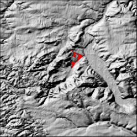
Fig. 2-1: Relief picture of the city of Stuttgart and the surrounding region
| |
Stuttgart's centre and the actual basin are situated off the Neckar in a Keuper sink (the market square is 245 m asl.), which was formed by the Nesenbach stream and its tributaries. The Nesenbach comes from Kaltental, passes through a narrow valley and enters the city basin near Heslach after 2 km. With an inclination of 5 to 10 degrees, the slopes of Stuttgart's elevated outskirts tower 100 to 240 m above the city basin, which runs from Southwest to Northeast and is about 6 km long. Northeast of the Karlshöhe crest, the basin forms the city centre which is up to 2.5 km wide. The Nesenbach valley is sharply narrowed to about 1 km between the Kriegsberg vineyard and the Uhlandshöhe vantage point and it discharges into the Neckar valley near Bad Cannstatt. The significance of the Nesenbach valley for Stuttgart's aeration is similar to that of the Dreisam valley with its "Höllentäler" mountain wind system for the city of Freiburg/Breisgau.
Figure 2-1 is a shadow relief map and illustrates the topographic situation of Stuttgart's entire territory with its topographic particularities. The plan area for Stuttgart 21 is marked in red. Figure 2-1 was created, as well as figures 2-2 to 2-5, with the help of the digital surface model (DSM) by Baden-Württemberg's State Office for Statistics.
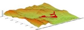
2.2 City centre with the plan area for Stuttgart 21The following pictures show different perspectives of the topographic situation of Stuttgart's city basin with the plan area for Stuttgart 21 marked in red. The plan area flanks the axis of the Nesenbach valley before it discharges into the Neckar valley.
|  |
Besides the elongated Nesenbach valley, which stretches from Southwest to Northeast, Stuttgart's city basin also comprises what is called the west basin. These two parts of the valley are separated by a ledge, which constantly descends from Birkenkopf (511 m asl.) over Hasenberg (457 m asl.) to Karlshöhe (343 m asl.) and finally ends at Silberburg (287 m asl.). The ledge forms the southern border of the wind-sheltered west basin. In contrast to this, the ledge strongly canalises the wind in the Nesenbach valley, which includes the city centre.
What affects the local climate around the plan area for Stuttgart 21, besides the axis of the Nesenbach valley, is the ridge separating Stuttgart's city basin from the parallel Feuerbach valley in the Northwestern. The Feuerbach valley is the extension of the Glemswald forest and also begins at Birkenkopf and stretches to the Neckar. It is interrupted by Pragsattel (305 m), an important northern passage for the city traffic. The Wartbergklinge and Steinbergklinge clefts (as part of the "Green U" on the area of the IGA garden show) descend from Killesberg to Heilbronner StraÃe. This sink can be followed in the course of the former Störzbach valley along EhmannstraÃe to the lower castle gardens. The Störzbach valley, which was partly overbuilt by the depot and the parcel post office, affects the plan area for Stuttgart 21 in the North and forms the border to Rosensteinpark. Besides the Störzbach valley, there are other clefts descending from the above-mentioned ridge to the Nesenbach valley which affect the local climate around the plan area. Among these clefts are Eckartshalde, which enters the Nesenbach valley around the Pragfriedhof cemetery, and Mönchhalde, which can be followed from the projecting Kriegsberg (365 m), strongly narrowing the city basin, over TürlenstraÃe and to WolframstraÃe.
Block diagrams of the city of Stuttgart
|
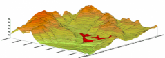 | | 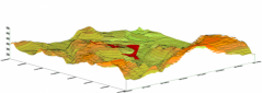 |
Fig. 2-2: Northeastern perspective on the city basin and the plan area for Stuttgart 21 (in red)
|
|
Fig. 2-3: Southwestern perspective on the city basin and the plan area for Stuttgart 21 (in red)
|
|
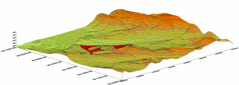 | | 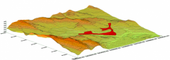 |
Fig. 2-4: Northwestern perspective on the city basin and the plan area for Stuttgart 21 (in red)
|
|
Fig. 2-5: Southeastern perspective on the city basin and the plan area for Stuttgart 21 (in red)
|
| |

|
 |
|
| © City of Stuttgart, Office for Environmental Protection, Section of Urban Climatology |